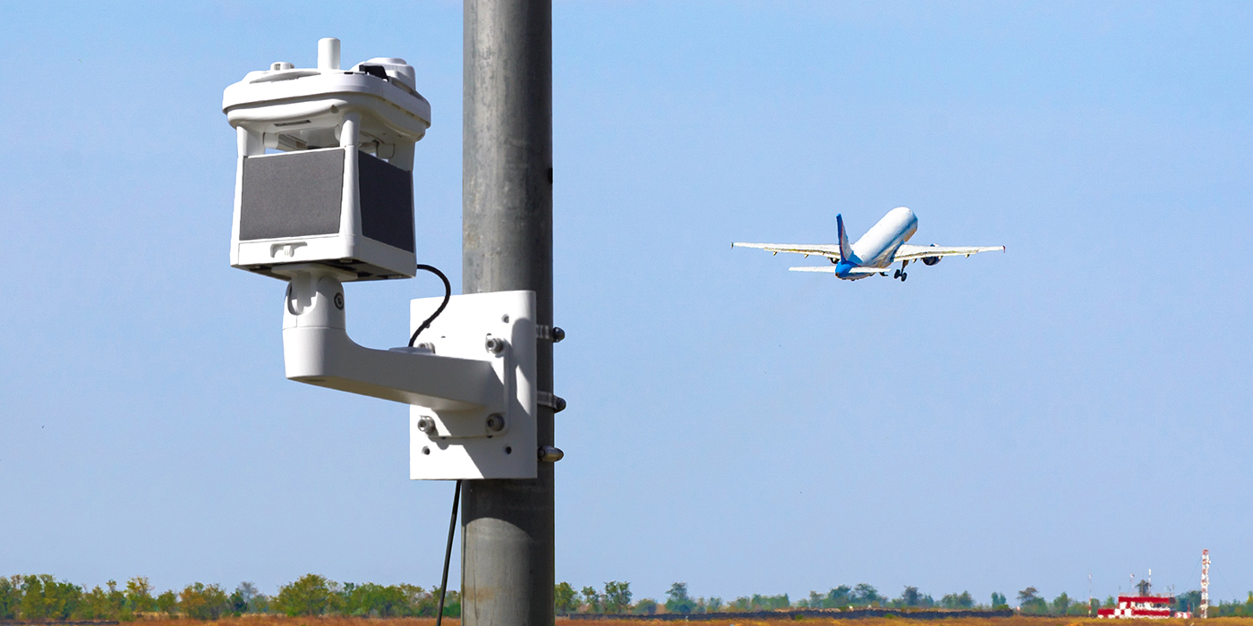
As air traffic increases and aviation technology evolves, so does the need to gather more accurate weather data. Now airports can bolster aviation safety with the Micro Weather Station from Intellisense Systems.
With passenger jets grounded and incidents generating national headlines, aviation safety remains at the forefront of travelers’ minds. While air travel remains the safest method of transportation, the greatest impediment to aviation safety and timeliness is weather. According to the U.S. Federal Aviation Administration (FAA), bad weather causes almost half of all air traffic delays.
The problem is only worsening in light of climate change. The FAA found that more frequent thunderstorms in Florida in 2022 produced more weather delays across the state’s many airports than in previous years. Additionally, extreme heat in the summer of 2023 caused lower air densities and less lift for aircraft, resulting in further delays as air traffic controllers waited for temperatures to cool. To improve aviation safety and timeliness, airports require more environmental monitoring to account for rapid changes in local weather conditions.
For some airports, however, current weather-monitoring tools aren’t enough. Weather forecasts, while generally more accurate than in years past, observe the environment on a synoptic or mesoscale and may not capture the most proximate weather conditions on an airport runway. While most large airports use sophisticated and accurate automated weather observing systems (AWOS) to capture immediate, on-the-ground weather observations, these weather stations are expensive, with costs usually exceeding $100,000. They are also pricey to install and maintain, making them unaffordable for smaller airports and airfields.
 This is where the Micro Weather Station (MWS®) comes into play.
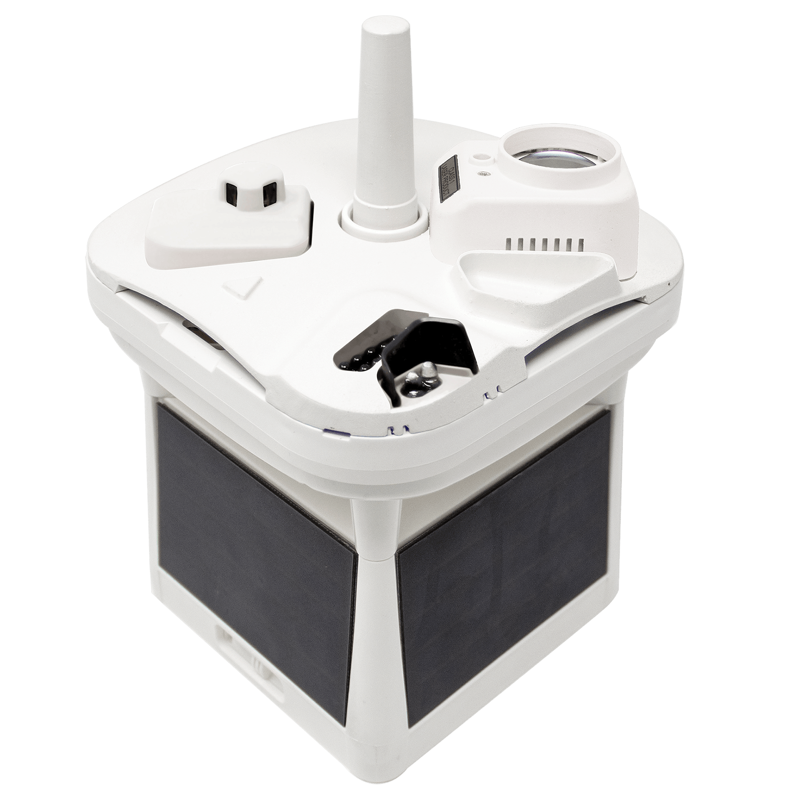
Compact, wireless, and completely autonomous, the MWS delivers a myriad of weather observations and is a smaller, more cost-effective, and easier to maintain solution than current weather-monitoring tools for aviation operations. The MWS reports two dozen environmental parameters over an Iridium satellite or LTE-M cellular connection. Thanks to its integrated solar power system and built-in battery pack, the MWS can monitor weather data even in extreme weather events when the power is out. With hardline power and serial connectivity, the MWS can generate a meteorological report every 30 seconds so that pilots and air traffic controllers can get the most accurate weather data at a moment’s notice.
But those features just scratch the surface of the MWS’s capabilities. Here are four ways in which the MWS can improve aviation safety:
Weather Data on the Highest Resolution Scale
While atmospheric modeling and computer algorithms can generate relatively accurate forecasts, most models can only capture weather data from a broad range of observations over hundreds of miles. Unfortunately, low resolution mesoscale environmental data cannot account for local terrain effects that can result in greater turbulence and wind shear. Additionally, atmospheric models perform poorly in a relatively small areas where unpredictable weather events like thunderstorms and tornadoes can occur.
The MWS provides the most flexible way to monitor weather data on a microscale. Unlike AWOS equipment that must be permanently emplaced at an airport, multiple MWSs can be easily transported and mounted near runways in need of more hyperlocal weather conditions or at improvised landing areas. Measuring eight inches tall and weighing just under five pounds, the MWS can be installed almost anywhere to gather critical environmental data near runways and helipads.
Built for Emergency Response and Readiness
Aviation for medical transportation and disaster relief carries people and resources to and from areas of need. However, some hospital helipads or airfields may not have the ability to monitor weather and safely transport patients via airplane or helicopter. Unless the treatment facility or resource center is located very close to an airport with weather-monitoring equipment, medivac helicopters and cargo aircraft may not have the weather information required to reliably transport people or personnel from affected areas.
The MWS delivers a reliable means of gathering environmental data when an AWOS or other weather-monitoring solution is unavailable. The MWS is built to military ruggedness standards to withstand the hazards of extreme heat and hurricane-force winds. In fact, the M625 model of the MWS has served in recovery efforts following a Category 5 hurricane in Florida, as well as in wildfire relief efforts in California.
Cloud Height Capabilities
Measuring cloud layer height is critical in aviation safety because it determines visibility at flight level during approach and the potential for rainfall. Low-level clouds at 2,000–3,000 feet above ground level typically pose the greatest threat to aircraft landings because they produce poor visibility, turbulence, icing, and runway contamination. As a result, all aviation operations require cloud height measurements to ensure flight safety and success.
To best serve the needs of aviation operations, the MWS-C600 and M625 incorporate the world’s smallest lidar ceilometer that can report cloud height up to 10,000 feet. This innovation not only gives pilots and air traffic controllers this important information, but its small size and lower cost makes this data more accessible to a wider swath of aviation operations as well. Unpaved, unmanned, or unattended airfields can now reliably receive cloud height data thanks to the capabilities of the MWS.
Visibility, On-site Imagery, and More
Although fatal aviation incidents have fallen steadily over the years, the highest probability of a deadly accident occurs during landing. Studies found that 49% of all fatal accidents happen during the final descent and landing phases of flight, with the root cause being pilot error as the result of low visibility. To improve aviation safety, the FAA establishes safe visibility minimums at several distances, such as visibility of at least one mile on an approach at a 5,000-foot altitude. So for approaches under visual flight rules, pilots need visibility measurements of at least one mile.
In addition to its lidar ceilometer, the C600 model of the MWS includes a visibility sensor with a range of 6.2 miles and a resolution within the nearest 300 feet. The C600 also features a 360-degree panoramic camera, which is not found on an AWOS. This capability delivers on-site imagery for remote or unattended airfields where observations are limited.
The MWS is a proven and reliable weather-monitoring solution for a multitude of aviation applications. It can make airport operations more efficient and keep the skies safe for pilots, passengers, and crew.
